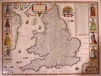
Who Maps the Mapmakers?
 My friend and mapmaker Jo Walsh (aka zool) writes:
Why is it that most cartographers are hopelessly lost? Maybe I'm speaking from experience, but it seems like mapping, despite being one of the oldest exploratory traditions, is still quite young. Some people seem to think the world has already been discovered by people like Columbus and Magellan, but I think they just scratched the surface.
so they're looking for a killer RDF app, like everyone else. i maintain that the solution and the problem are the same thing; not a killer app, but a thousand interlocking sub-apps, enhancing each other; the swarm of bots, propelling themselves about a fluid continuum."
Jo gets it. She knows the power of RDF coupled with geo technologies. Defining space is about the name space and semantics. Trying to get well established companies and government cartography institutions to open up is a bit like trying to get your cat to take a bath. Even in countries like the United States, where government maps are more open, they still aren't reliable enough to use for generic things like driving directions, and the only other option is to lease expensive geographic feeds from companies like Mapquest and ESRI.
In this writer's opinion, community and open-source developers will be the ones forging the emerging cartography world, not a business model or better PDAs. Jo is the smartest girl I know, and possibly the smartest geek I know. The Ordinance Survey could greatly benefit the people of Britian if they open up and listen to cartography pioneers like Jo Walsh, who are often all too eager to hack shit up in the name of progress.
[Link from www.zooleika.org.uk]